5 Great Tech Tools For Landowners
By Tallon Martin, Broker Associate, Republic Ranches
If you have ever been in an old rancher’s truck, I’m sure you’ve glanced around the dusty cab at the scattered files lining the dashboard, tractor parts catalogs tucked under the trusty beat-up rifle, wondering how they keep up with it all. You quickly realize there is a method to their madness, and though their organizational skills may be questionable, they are some of the sharpest people you will ever meet. They have an incredible ability to remember fine details. I blame my fleeting memory on being able to quickly pull things up in a Google search on my phone. There is no deprogramming a bad habit this late in life, so if you find yourself memory-challenged like me, there are some excellent land management tools that can help keep things organized.
Farmlogs
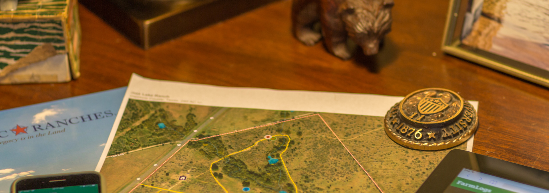
Farmlogs is one of the most potent land management apps I have found. It is very user-friendly and helps you record various land management data and tasks in one place. The mapping feature is powerful: you can map specific fields within your ranch in great detail. If it rains in that field, I get an email the next day telling me the software detected rain and how much rainfall there was in that specific location. You would think they would grab the closest weather station and send you that data, but it is much more site-specific and reasonably accurate. Several of us at Republic Ranches use the interface for personal and professional use. As an absentee landowner, this feature is beneficial, helping me plan before I make the trip to do fieldwork. I can also monitor the success of a food plot, pasture forge growth for livestock, and know when we have had consistent enough rain to burn brush piles. For each field I map, I can see recent rainfall, rain and heat history, soil maps, and make specific notes for that field (i.e., what I planted, the rate at which I seeded, and the amount of fertilizer/herbicides I applied). The more data and notes you put into it, the more trends will become apparent to you over time.
Seek by iNaturalist
Seek has to be one of the coolest apps I have learned about recently. I have used several of these apps over the years, all of which have been pretty unsuccessful at accurately identifying plants. This app seems pretty accurate, and it is real-time, which is a lot of fun. You point your phone camera at a plant, insect, or animal, and it tells you what it thinks it is. I have been pretty shocked at how fast it figures it out. Seek is a great land/wildlife management tool; it allows you to identify plants you may not know, allowing you to expand your knowledge base. If it is a common plant in Texas, there will almost always be an article on the Texas A&M Agrilife site (or your local Ag Extension) explaining its benefits to your ecosystem or how to manage it if it is undesirable. It is also fun for the whole family. My daughter and I were sitting on the ranch house’s back porch and had a beautiful bright red and black bird land near us. I pulled out my phone and snapped a shot, and it immediately told me it was a Vermilion Flycatcher. We have never seen one there, and it was fun for us to experience that and learn together.
MapRight
If you have looked at any ranch real estate over the past few years, you have probably seen MapRight before. It has taken our industry by storm, and we use it for an array of purposes. I have found that it has personal applications for landowners as well. You can build custom maps and apply layers and labels to locations on your ranch. I use it to map out yearly plans for projects I want to complete, and it helps me get a big picture of tasks and inspires me to work on neglected areas. I enjoy sitting down with clients during the buying process to map out ideas on transforming land and adding impactful value over the investment life. I have seen clients transform some pretty raw acreage into beautiful ranches because we could build a visual plan together that helped them picture their desires. If you have no desire to geek out on map building but would like a high-resolution boundary map of your place, please reach out.
Hunterra
If you have ever walked into a friend’s ranch house and seen a large ranch map blown up on the wall and found yourself drawn to it, you will like this tool. Hunterra is more of a one-time tool but is worth checking out. It is another mapping tool, but the standout feature this platform offers is printing large maps. One of my favorite options is the magnetic map. If you are entertaining a lot and want to assign guests to specific hunting spots, you can place color-coded magnetic markers on each guest’s designated site. This gives you and guests a clear picture of where everyone is in the field. They also make some pretty cool waterproof maps to keep on hand in the Polaris or hand out to hunters if someone ventures off to track down a downed animal and needs to tell you where they are.
Spypoint Cameras
When I was a kid, I remember trail cameras used to look like a large pelican case you strapped to the tree, and then you had to set up an external solar panel to keep it from dying. It has been pretty amazing to see the advancements in that arena. The company that has come out of nowhere in the last few years is Spypoint cameras. I love Spypoint for how inexpensive they are, the ease of setup, and their solid app. There are higher quality, more expensive options out there, but for $100 and a low-cost monthly subscription, it is nice to be able to put a lot of cameras out and not worry about them. I have been impressed with their battery life and durability, and it is enjoyable to get daily picture downloads to your phone. I can track wildlife movement on specific trails during the rut or monitor vegetation growth on my duck unit during the spring. These cell cameras are also great for ranch security, and some clients have higher image quality cameras at their front gate. They get a notification as soon as someone pulls in, and it immediately gives you a clear picture of the driver, license plate, and make of the vehicle. You can imagine the endless applications for these cameras.
On top of the apps mentioned above, we use various databases and GIS systems to research prospective properties for clients to ensure we have an accurate picture of the ranch and any unforeseen negatives. Before even putting boots on the ground, we can see new and old oil and gas activity on or around the ranch, groundwater availability and strength, and “renewable” energy activity on or around the ranch. We can also review historical aerial data to understand surface water fluctuations during dry years and any historical surface disturbances that may be covered up now. If you have any questions about your “neighborhood” or want to dig deeper into a property that has caught your eye, I can reasonably quickly give you a clear picture. It is incredible to see the creative tech ideas built during my time, and I can only imagine where we will be 20 years from now. Apps have already transformed ranch management significantly, and it will only get better from here.
Discover the Charm and Opportunities of North Dakota
Are you considering a move but unsure where to settle? North Dakota, often overlooked by travelers and potential residents alike, offers a wealth of opportunities and a lifestyle to suit a variety of preferences. Whether you’re drawn to outdoor adventures, a slower pace of life, or expanding career opportunities, this charming state has something to […]

Easement Dispute – Ask an Agent
Dear Land Expert, I am preparing to list my Western ranch soon; however, my neighbor is currently contesting an easement that crosses a corner of their property, an access route I’ve used consistently and that has been essential for reaching certain parts of my land. While I’ve always understood this to be a valid easement, […]